
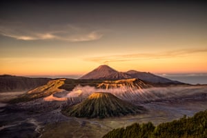
Tengger volcanic complex, Indonesia.
-
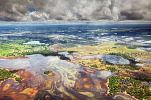
Pantanal, Brazil
The world’s largest freshwater wetland, the Pantanal covers more than 180,000 sq km of western Brazil and parts of Bolivia and Paraguay. This image shows one of its vast plains, 80% of which are inundated during the wet season – with water levels rising by up to five metres.
-
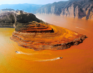
Yellow river, China
This is the third-longest river in Asia, and the most silt-laden river on Earth. It takes its name from coloration by the fine, wind-blown sediment, known as loess, that it carries along its lower course. The river flows through deep gorges, as seen in the image, before it descends on to the North China Plain.
-
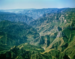
Copper Canyon, Sierra Madre, Mexico
Urique Canyon, part of the Copper Canyon system in the Sierra Madre Occidental, is the deepest canyon in North America, descending 1,870 metres from its highest point. The dimensions of Copper Canyon, or Barrancas del Cobre, are comparable to those of the Grand Canyon in Arizona, US.
-
Drakensberg, southern Africa
Drakensberg, which means Dragon’s Mountain in Afrikaans, is the eastern part of a long, winding slope called the Great Escarpment. It’s the edge of a high plateau of central southern Africa and in places the escarpment is 1,500 metres from base to top. The part shown in the photo is shaped like an amphitheatre: the pinnacles on the right are known as Dragon’s Teeth.

-
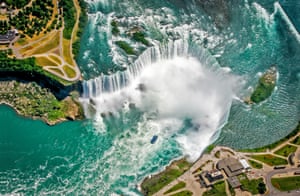
Horseshoe Falls, Niagara Falls, Canada-US
Niagara Falls was formed as the Niagara river plunged over an escarpment on its way to the Atlantic Ocean. In a process that continues today, the river eroded layers of soft rock that sat below a harder dolomite caprock. As the soft layers eroded, great chunks of the caprock gave way, leaving a vertical cliff face.
-
Angel Falls, Venezuela
Angel Falls is the world’s highest uninterrupted waterfall; in its uppermost few hundred metres, the water barely makes contact with the sheer sandstone cliff behind.

-
Tengger volcanic complex, Indonesia
This is part of a national park on the Indonesian island of Java that lies within a large caldera – the remains of an volcano that erupted more than 45,000 years ago. In this view, the volcanic cones comprising the Tengger complex are at the centre, with smoke coming from Mount Bromo. In the distance is Mount Semeru.
-
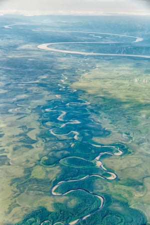
Yukon river, Canada
For much of its lower course, the Yukon is a slow, winding river with many large meanders and oxbow lakes scattered throughout its floodplain. It is the third-largest river in North America, after the Mississippi and the Missouri, but despite this only four bridges have been built across it.
-
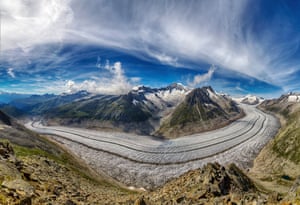
Aletsch Glacier, Switzerland
The largest glacier in Europe is 23km long and covers an area of about 80 sq km. It is formed by the merger of four smaller glaciers that originate on the southern flanks of the Jungfrau and Monch mountains.
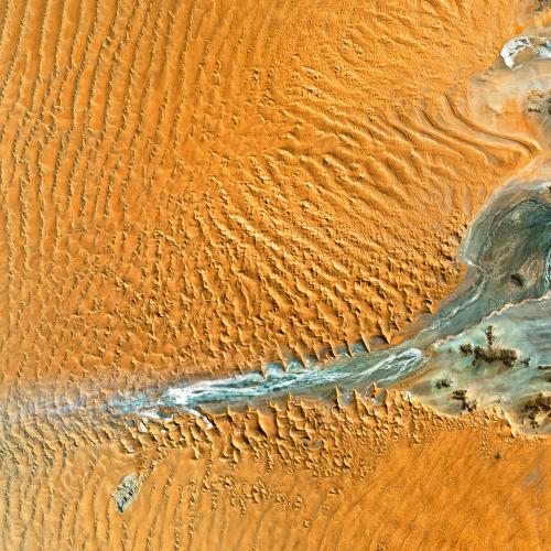
Namib-Naukluft national park, Namibia
Captured in visible light and infrared, these sand dunes are in Africa’s Namib Desert. Winds blowing off the Atlantic Ocean produce some of the world’s highest dunes here, some reaching heights of 300m.
-


